
ALTOSTRATUS  INC.
Menu
  • External link opens in new tab or window
  • External link opens in new tab or window
  • External link opens in new tab or window
  • External link opens in new tab or window
  • External link opens in new tab or window
  • External link opens in new tab or window
  • External link opens in new tab or window

Services

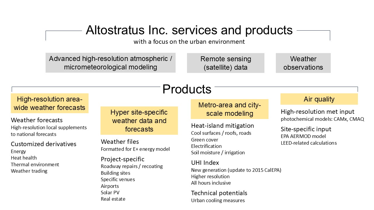
Altostratus Inc. has successfully and cost-effectively completed numerous projects for federal, state, local, and other agencies consistently ahead of schedule and on or under budget. Altostratus Inc.  also has a record of successful completion of projects that advance the consideration of scientific concepts, RD&D products, and control measures in the research and regulatory environments.


Scroll down through this page for a description of services -- also see Dr. Haider Taha's experience in the page "About Us".


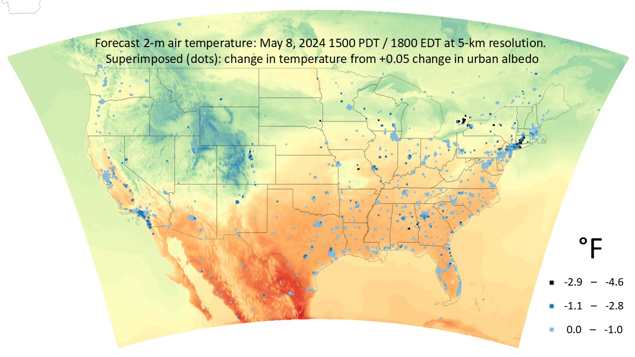
Altostratus' work and various projects in meteorological, emissions, and photochemical modeling led to the consideration by and support from US EPA, AQMDs, cities, and local governments of the “Cool Cities” family of measures to reduce urban heat, improve air quality, and reduce cooling energy use. Altostratus has completed projects to quantify the benefits of surface modification measures (e.g., cool roofs, cool pavements, solar PV, vehicles electrification, and urban forests, among others) some of which were considered in clean-air plans, such the Bay Area and South Coast AQMDs. Altostratus also completed a regulatory atmospheric modeling project to develop an urban-forest control measure for the ozone State Implementation Plan of the Sacramento region. It also completed a project for the Cal/EPA in which it developed a first-of-its-kind Urban Heat Island Index for the state of California and a project for Caltrans / Sacramento Metropolitan Air Quality Management District that developed a heat-mitigation plan for the Greater Capital region. See the projects page for more information or contact us for details.


Computational resources at Altostratus Inc. include multi-processor, high-performance Linux platforms fully dedicated to atmospheric modeling, research, and analysis. Models are continuously maintained, updated, and optimized for various applications. Software needed in data processing, visualization, and statistical analysis are fully configured. Most recent meteorological and surface input datasets are tested, enhanced, and improved , and new data frequently acquired for more accurate modeling at various scales.


Column


Research services:


  • Regional, mesoscale, sub-mesoscale, and high-resolution meteorological modeling (customized WRF, uWRF, MM5, uMM5) for a range of applications, including climate, energy, emissions, and air quality
     

  • Mesoscale and sub-mesoscale emissions and photochemical air-quality modeling and analysis (SMOKE, BEIS, CAMx, CMAQ, UAM-V) for research and regulatory applications
     

  • Fine-resolution, sub-kilometer urban meteorological modeling (customized uWRF model) for research, regulatory, and forecasting applications, including generation of fine-scale microclimate zones for energy modeling and forecasting
     

  • Coupled regional and global models; dynamical downscaling of general circulation models for local-impact assessments and forecasts (e.g., GFS, CCSM4, uWRF)
     

  • Fine-resolution  meteorological and photochemical modeling in conjunction with dispersion modeling (e.g., AERMOD applications)
     

  • Development and update of prognostic models and tools for use in urban / environmental planning, sustainable development, urban heat-island studies, and evaluation of mitigation or control measures under present-day conditions, future-year emissions, and future land-use scenarios.


  • Column


    Forecasting, weather data, and air quality:


    • Site-specific, tailored high-resolution weather forecasts

    Highly site-specific, fine-resolution short- and long-term weather / micrometeorological forecasts are tailored specifically to the location and needs of the client's industry and application (examples include energy / utilities, public health, agriculture, AERMOD dispersion modeling, LEED-credit weather modeling, water usage, emissions, transport, or siting of weather monitors). The meteorological models are configured and customized for the specifics of each site, including fine-scale characterizations of land cover, morphology/topography, surface and soil properties, surrounding areas (especially upwind), local sources of heat, and geometrical features. These characterizations are based on site visits, remote sensing, and aerial imagery among other sources of information. Models are tested to ensure satisfactory performance. Suitable model physics and parameterizations are customized and adapted specifically for each site. Observational data are ingested and assimilated in real time as needed. Contact us for sample weather forecastsExternal link opens in new tab or window (also see the forecasting page and sample forecast report).


    • Site-specific weather for building energy modeling and analysis

    Advanced, fine-resolution meteorological modeling at Altostratus (mod-uWRF, mod-uMM5) is carried out to create probabilistic fine-resolution, site-specific weather (weather files) formatted as input to building energy models such as DOE-2 and EnergyPlus, among many others. Altostratus' approach of generating weather files takes into account not only the changing atmospheric fields but also the changes in land use and land cover that are expected to occur in the future, including urbanization and modifications to surface physical properties. For both current and future conditions, this approach is a significant improvement over the traditional use of coarse-scale weather files (e.g., TMY, TRY, WYEC, etc.) and coarse climate zoning in current building energy modeling that are seldom representative of the conditions at the site of interest. For current climates, Altostratus models also ingest observational meteorological data from weather stations in the area (e.g., mesonet and urbanet) along with detailed characterizations of land cover and urban morphology. Using model-generated site-specific weather (for any desired time period and location) can significantly improve the accuracy of quantifying building energy use throughout the design and operation phases and in complying with codes. Contact us for more information or for sample weather files developed for EnergyPlus. You can also view an article on weather files, by Altostratus, in External link opens in new tab or windowIBPSA News, Volume 30, Number 2, pp. 29-41 or visit the weather files pages and sample article.


    • Urban meteorology, emissions, dispersion, and air-quality

    In addition to the research- and regulatory-grade meteorological, emissions, and photochemical / air-quality modeling capabilities and projects at Altostratus Inc. discussed elsewhere on this website, extended capabilities are developed for fine-scale urban meteorological and air-quality forecasting (sub-kilometer resolutions). Building upon updated urban canopy-layer parameterizations, the models' days-out forecasts are evaluated on an on-going basis. In relation to this effort, the parameters input to the models are also updated to provide area-specific information. To improve the accuracy and spatio-temporal resolution of characterizing source emissions, transport, and fate of air contaminants in urban areas, Gaussian plume dispersion models are linked with fully dynamical micro- and meso-scale meteorological models to provide real-time local drivers to dispersion calculations. These capabilities can also be used to generate site-specific, fine-resolution meteorological input to regulatory-type dispersion modeling of new or modified sources to demonstrate compliance, e.g., with EPA-recommended models like AERMOD.


    Copyright 2018 ALTOSTRATUS INC.


    • Services
    • Projects
    • Research
    • Publications
    • About Us
    • Contact Us
    • External link opens in new tab or windowLinkedIn
    close lightbox